With the official start of hurricane season in June, Midland's meteorologist, Bruce Jones shared the lessons we should all learn and take with us for preparedness.
About Hurricanes
The Atlantic Ocean hurricane season runs from June 1 to November 30, encompassing the hottest half of the year; 183 days of tropical storm potential, when warm water and light winds allow areas of low pressure to build into tropical depressions, tropical storms, and potentially, hurricanes.
A tropical storm becomes a hurricane when wind speeds reach at least 74 miles per hour, a category 1 storm.
The highest wind speed ever recorded in an Atlantic hurricane was an astonishing 190 mph in 1980’s Hurricane Allen, a category 5 storm.
Many people in coastal hurricane zones gauge their interest in an oncoming hurricane by the strength of those winds. Some will evacuate their coastal homes when any hurricane is due, regardless of its category. Others maintain they will only leave if the hurricane is category 3 (winds 111-129 mph), and others say they won’t even run from a dreaded category 5 (157+ mph). As a meteorologist, I encourage everyone to err on the side of safety. There are countless stories of people on the coastline who stayed in their home to ride out a hurricane, only to pay with their life, or the life of a loved one. Once the winds start blowing, trees and power lines can block escape, and bridges to the mainland will be closed. Better safe than sorry; so if possible, leave early and live.
Categorizing Hurricanes
Our method for judging the strength or “category” of hurricanes is based on the decades-old Saffir-Simpson scale, which ranks the storms primarily on their wind speed.
Forecasters predict the winds of Hurricane ABC will be 96-110 mph, so they tell us, “Hurricane ABC will make landfall as a category 2 storm”, and we all make our plans in reaction to this wind-based forecast. What could be wrong with that? Plenty.
The majority of damage in hurricanes, and the majority of deaths (85%), come not from wind, but from water. Alarmingly, most of those water-based deaths are due to inland freshwater flooding, often hundreds of miles form where the hurricane comes ashore. 2024's Hurricane Helene made landfall in Florida, but only 14% of all deaths occurred in Florida, where the hurricane's storm surge was recorded by this beachside camera:

Image: USGS, via National Hurricane Center
Such coastal storm surge is deadly, but the vast majority (86%) of Helene's 248 fatalities occurred in the Carolina's, Georgia, and Tennessee, where extreme torrential rainfall led to catastrophic flash floods and deadly landslides. At the same time, these storm surge photos were taken in Madeira Beach, Florida, the National Weather Service was warning areas 600 miles north to prepare for an event so dangerous it had never been seen before.

Image: NWS-Greenville/Spartanburg SC
Alerting of Storms
We can be alerted for something we have never experienced before, but once we are told a catastrophe of historic proportions is possible, how do we know how to act, what to do, where to go, and how to prepare? What do we have to compare it to?
In North Carolina, some were old enough to recall hearing Grandad's stories of the Great Flood of 1916, itself triggered by flash flooding from a dying tropical storm. National Weather Service forecasters said with somber certainty that Helene's floods would be worse. Many people headed the warnings and were able to relocate away from creaks, streams, and vulnerable hillsides. Many others discovered too late that escapes routes were blocked, flooded or closed to traffic. In the mountains of the Carolinas, Georgia, and eastern Tennessee the storm's rainfall impact truly lived up to its frightening forecast.
A New Hurricane Scale
At the 2026 American Meteorologist Society Conference in Houston, meteorologist Logan Allen Giles proposed a new hurricane scale that incorporates not only the dangers of wind, but also the water dangers incurred through storm surge at the coast, and inland flash flooding from incessant rain.
Take a look at the below chart, combining the current Saffir-Simpson wind speed and category rankings with Logan's proposed "Giles Scale" of water threats.

The Giles Hurricane Scale could save your life.
People in the mountains of the Carolinas live in an area that rarely needs to consider the wind-based Saffir-Simpson scale, and they were hearing about a hurricane landfalling 600 miles away. The Giles Scale of rainfall threat shows that the massive Carolinas/Tennessee downpours of September 24-28, 2024 placed some areas into the "Category 4" scale of rainfall impact, which could have significantly improved individual response to the watches and warnings for these unprecedented floods. After all, if you lived on the coast, and a Category 4 storm was coming at you, you would immediately comprehend the danger of that threat.
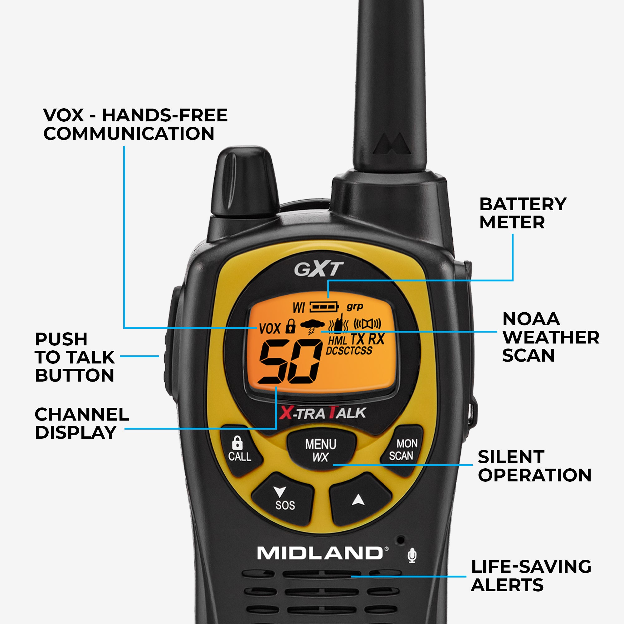
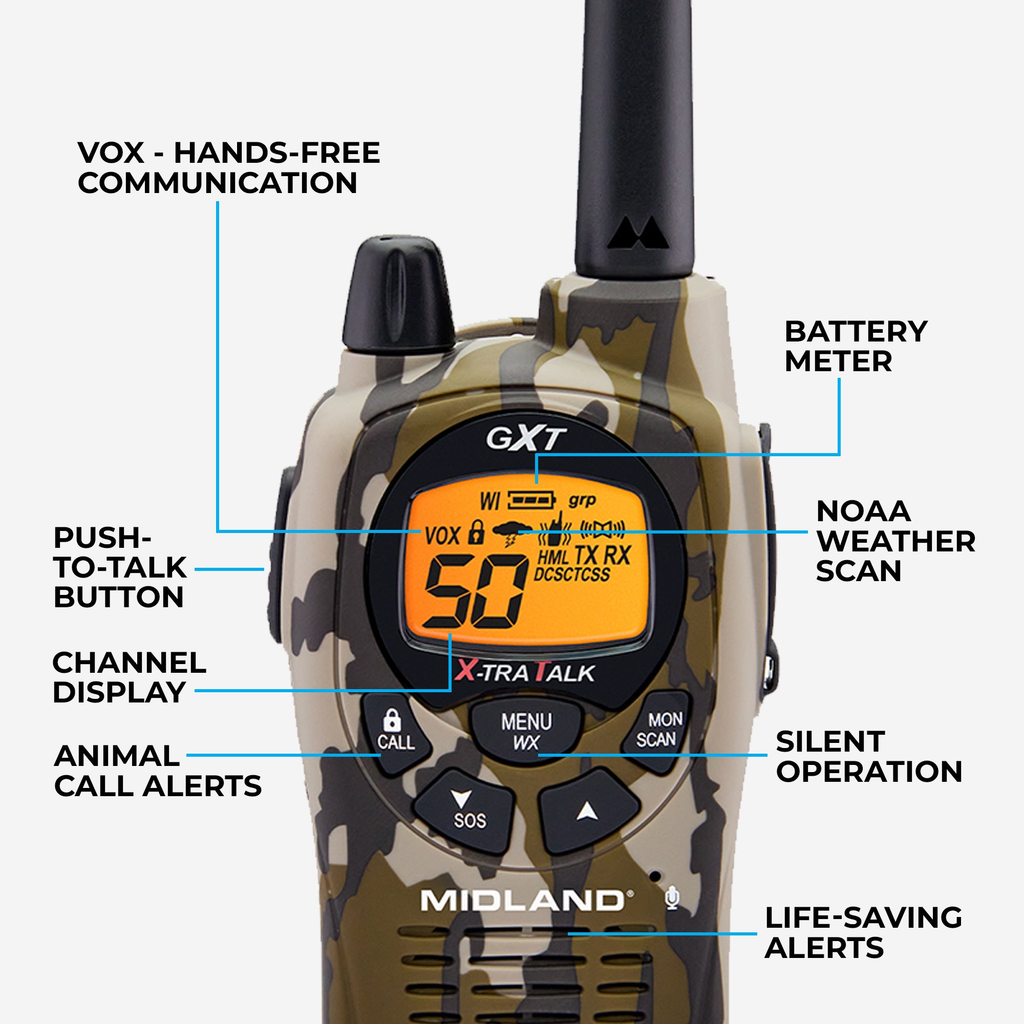
Importance of NOAA Weather Radio
Helene's inland devastation was so complete that electricity, cell phone service, and internet were knocked out. Billions of dollars in flash flood damage left more than 4 million electric customers without power, many of them for weeks on end. In the midst of this catastrophe, throughout the event and afterwards, the only thing that worked was good old radio. NOAA Weather Radio, the official "Voice of the National Weather Service," was a non-stop lifesaver for thousands, delivering instant alerts for numerous Flash Flood Emergencies, evacuation notices, and Civil Emergency Messages before, during, and after the rain.
For first responders, two-way radio was the most available and reliable way to communicate, proving when things are at their worst, radio comes through.

Numerous NOAA Weather Radio stations in the flood area kept every county safe and informed. Image: NWS-Greenville/Spartanburg SC
Improvements to Forecasting
The National Hurricane Center and the National Weather Service are constantly improving both forecast accuracy and the delivery of understandable and impactful warnings.
To prepare for this year's hurricane season, follow here and consider making radio an important part of your family preparedness plan.
Getting a NOAA Weather Radio
First, get an inexpensive NOAA Weather Radio so you can receive instant alerts sent automatically by the official authorities: The National Weather Service and your county emergency manager.
For homes, schools, and businesses, a Public Alert-certified weather radio like Midland's WR120 NOAA Weather Radio operates much like a smoke detector, silently monitoring the NOAA broadcast, and instantly alerting you to the moment a watch or warning is issued for your country. Its 8-decibel alert tone makes sure you'll know when danger threatens you, day or night.

Secondly, because power outages can wreak havoc on your life and safety, make Midland's new ER310PRO Portable Emergency Crank Radio with Power Bank your all-in-one "go kit" radio.
Its powerful battery lasts over 200 hours and can charge up your phone. Not to mention, you can also power it up with solar power and a high-quality hand crank. It also includes AM/FM radio, NOAA Weather Radio, a powerful flashlight with SOS strobe, and Bluetooth® streaming.

Every hurricane season brings a risk of danger, but hurricanes are not just giant wind machines. Days after they come ashore, they can generate flash floods of historic and catastrophic proportions hundreds of miles inland, perhaps in your neighborhood.
Have a plan, be prepared, and monitor only trusted sources of information, like your local National Weather Service office and the National Hurricane Center. They are your best bet for real, accurate, life-saving information, and with NOAA Weather Radio in your home, you'll receive their warnings and watches the moment they're sent out. When all else fails, good old radios work, and the greatest radio alerting system in the world is "America's Official Federal Warning System"- NOAA Weather Radio.


Share:
Introducing ClipTalk- Midland's Wearable, Mini Walkie Talkie
GMRS Walkie Talkies Transform Safety and Efficiency on Farm